ULTRA TRAIL
DO MARÃO

For more information or any questions, please contact us. Amarante, Portugal. Amarante, Portugal
Amarante, Portugal
geral@utmarao.pt

OFFICIAL CHANNELS:


MTM

This race starts right in the centre of the beautiful village of Baião, nestled between the Aboboreira and Castelo de Matos mountains. These two magnificent mountains together house Portugal’s largest open-air megalithic museum.

Baião is a place that surprises those who visit it. A land of mysticism and magic. And a benchmark destination for sustainable tourism. From here, you will ascend to the plateau of the Aboboreira mountain range, following trails with magnificent landscapes, and then descend to Aldeia Velha. You will run along centuries-old trails, through a lush forest and past the beautiful Goiva waterfalls. It is an excellent opportunity for those looking for a very short distance, but maintaining the identity of the Marão mountain range.

Let yourself be enchanted!

DOWNLOAD GPX
DOWNLOAD KML

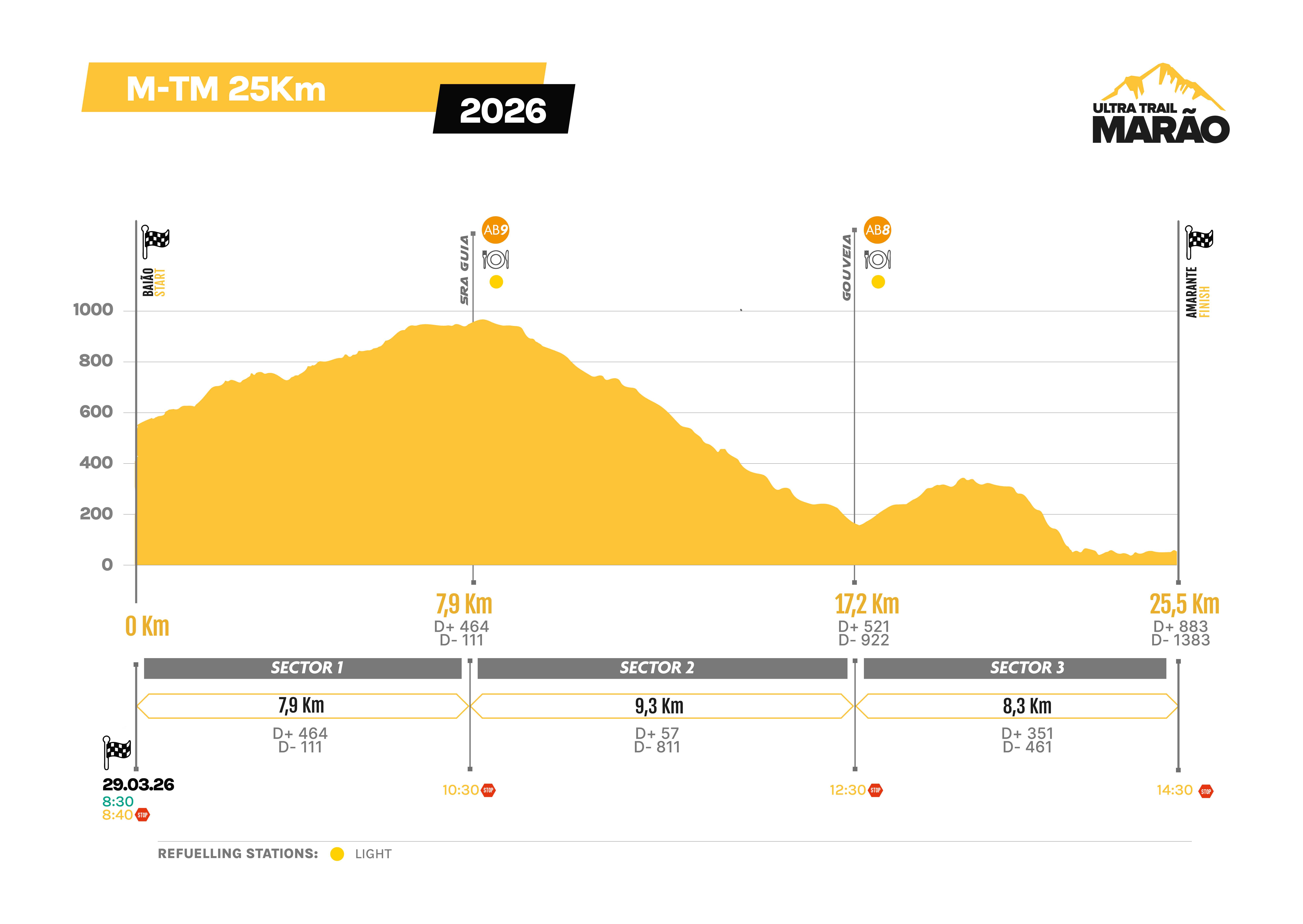
25 km
1000m D+
6 HOURS LIMIT

Sunday, 29 March 2026
07:10 – Transport to Praça Dom Manuel de Castro, Campelo – Baião, MTM 25K | Location: Avenida General Silveira
8:30 – Start (Praça Dom Manuel de Castro, Campelo – Baião)
Time limit: 6 hours

25 km and 1000 m elevation gain
Maximum elevation: Abogalheira, 902 m
Minimum elevation: Pista do Formão, 58 m
1 mountain range, 1 mountain chain
Difficulty level: (1000/10)/25 = 4 pts
Itra: 25 + (1000/100) = 35 pts

The rural trails of the villages of Aboboreira.
The megalithic necropolis of Aboboreira.
The superb panoramic view from Sra. da Guia.
The peaceful cosiness of the unique village of Aldeia Velha.
The exuberant waterfalls of Ribeiro da Goiva. And much more!

DOWNLOAD GPX
DOWNLOAD KML

BAIÃO – SRA. DA GUIA

Starting from the Baião Town Hall, you will travel along a network of rural trails. These are magical places of great beauty, stretching all the way to the Aboboreira mountain plateau. Here, adventurers are treated to superb panoramic views as far as the eye can see. And when you see the various dolmens in situ, you are invited to feel as if you have travelled back in time to the days of our ancestors, thousands of years ago.

8.3 km / 492 mD+ / 104 mD-
Maximum time: 2 hours
Time limit: 10:30 a.m.
GPS coordinates: 41.19365;-8.02712

DOWNLOAD GPX
DOWNLOAD KML

SRA. DA GUIA – GOUVEIA (S. SIMÃO)

The mysticism of the Aboboreira mountain range and the traces found here are the perfect harmony for an encounter with our ancestors from thousands of years ago. This encounter ends as soon as you reach Aldeia Velha. The already bucolic scenery is quickly invaded by a succession of magnificent waterfalls that run along the Ribeiro da Goiva stream. You arrive at the S. Simão de Gouveia picnic park. Flanked by successive waterfalls, just after the supply point.

9.5 km // 57 mD+ // 807 mD-
Maximum time: 2 hours
Time limit: 12:30 p.m.
GPS coordinates: 41.2253;-8.07209
Team: SavageNatur Events

DOWNLOAD GPX
DOWNLOAD KML

GOUVEIA (S. SIMÃO) – AMARANTE

Descend to the Ovelha River. Take a short climb up an abandoned water channel.
In Salvador do Monte, after crossing the village, follow a short descent to the Tâmega River. Walk two kilometres along the river through a forest trail and arrive in Amarante. End of the challenge.

8.1 km // 334 mD+ // 449 mD-
Maximum time: 2 hours
Time limit: 2:30 p.m.
GPS coordinates: 41.26714;-8.08028

Sector 1

BAIÃO – SRA. DA GUIA

Starting from the Baião Town Hall, you will travel along a network of rural trails. These are magical places of great beauty, stretching all the way to the Aboboreira mountain plateau. Here, adventurers are treated to superb panoramic views as far as the eye can see. And when you see the various dolmens in situ, you are invited to feel as if you have travelled back in time to the days of our ancestors, thousands of years ago.

8.3 km / 492 mD+ / 104 mD-
Maximum time: 2 hours
Time limit: 10:30 a.m.
GPS coordinates: 41.19365;-8.02712

DOWNLOAD GPX
DOWNLOAD KML
Sector 2

SRA. DA GUIA – GOUVEIA (S. SIMÃO)

The mysticism of the Aboboreira mountain range and the traces found here are the perfect harmony for an encounter with our ancestors from thousands of years ago. This encounter ends as soon as you reach Aldeia Velha. The already bucolic scenery is quickly invaded by a succession of magnificent waterfalls that run along the Ribeiro da Goiva stream. You arrive at the S. Simão de Gouveia picnic park. Flanked by successive waterfalls, just after the supply point.

9.5 km // 57 mD+ // 807 mD-
Maximum time: 2 hours
Time limit: 12:30 p.m.
GPS coordinates: 41.2253;-8.07209
Team: SavageNatur Events

DOWNLOAD GPX
DOWNLOAD KML
Sector 3

GOUVEIA (S. SIMÃO) – AMARANTE

Descend to the Ovelha River. Take a short climb up an abandoned water channel.
In Salvador do Monte, after crossing the village, follow a short descent to the Tâmega River. Walk two kilometres along the river through a forest trail and arrive in Amarante. End of the challenge.

8.1 km // 334 mD+ // 449 mD-
Maximum time: 2 hours
Time limit: 2:30 p.m.
GPS coordinates: 41.26714;-8.08028

DOWNLOAD GPX
DOWNLOAD KML
PASSAGE TABLE
ATHLETE KIT
,,

The Marão UTM is an inspiration for those who seek to go beyond their abilities. the landscapes are so immersive that they disconnect us from our daily routines, and connect us to the power of nature and the energy of the earth. i love this connection. thank you, Marão

REGISTRATION
REGULATIONS